Friday, August 19, 2011

Fountain Of Joy - KRS

While coming back from Mysore, we had been to KRS dam, to witness the majestic dance of Cauvery (musical fountain).
The team included : Sujay, Sushmitha, Arjun, Ambika ,Mr.Nagendra , Mrs. Pushpa  and my mom(Mrs.Gayathri)


Gardens : The Brindavan Gardens, then called the Krishnarajendra Terrace Garden, on the Krishnaraja Sagar Dam site, one of the most beautifully laid out terrace gardens in the world. It is world famous for its symmetric design. The creative beautification of the whole dam complex has been the achievement of Sir Mirza Ismail, the then Dewan of the princely State of Mysore. The garden is designed based on the  ShalimarGardens of Kashmir in the Mughal style. The Department of Horticulture in 1927 started the work of laying out this garden.


The garden is enriched with fountains, terraces, parterres, running and cascadingwaterchannels, water chutes, lush green lawns, flower beds, shrubs and trees. This garden is a public park and it is one of the important tourist spots of India. The boating pond in the midst of the garden is a location where the visitors can enjoy a boat ride around the famous statue of Goddess Kaveri. It is a mesmerizing sight when the whole garden is lit up in the evenings. Today, the Brindavan Gardens is world famous for its ethereal beauty, grandeur and illumination/ musical fountain.


KRS Dam :The Krishnaraja Sagar dam is, one of the principal dams in South India.  The KRS dam, built across the river Cauvery is named after Krishnaraja Wodeyar IV. The Chief Engineer, Sir M. Vishveswaraya engineered the construction of the dam during the Wadeyar kings regime in 1932. It is built close to confluence of three rivers cauvery, Hemavathi & Lakshmana Teertha. The length of the dam is 2621 meters & height 39 meters. The reservoir itself is spread over an area of 130 Sq. Kms.
Fountain :The Musical and dancing fountain, located in the North Brindavan Garden, is the main attraction of the visitors. The water, coloured lights and music are synchronized fountain to create a water ballet controlled by an aquatic organ operated through a controller.  A laser show has also been developed for visitors’ attraction The illumination timing is the same as that for the garden. Crowds gather in large numbers at the gallery provided for the viewers.
Information to visitors 
The garden is maintained by the Senior Assistant Director of Horticulture, K.R.S.
Garden Timings: 6.30 A.M. to 9.00 P.M.
Facilities :Hotels and Inspection Bungalow provide with boarding and lodging facilities.
Transport :Many Government and private buses ply often from Mysore City to K.RS. K.S.R.T.C. buses also ply from Bangalore to K.R.S. and Mysore.
Illumination Timings :
JAN - SEPT :-Mon- Fri 7.00 to 7.55 p.m. 6.30 to 7.30 p.m.
OCT TO DEC :-Sat to Sun 7.00 to 8.55 p.m. 6.30 to 8.30 p.m. 


Wednesday, August 17, 2011

Splendour of Cauvery

 I had been to Chunchi falls with my cousins(Sujay and Sushmitha) who had come from USA. It was a trip to Nature's lap which is very near to Bangalore city. I visited Chunchi falls after 12 years.
Our plan was to cover Chunchi falls, Sangama , Mekedaatu and Shivanasamudram.
We left Bangalore on 28th July morning in a Qualis. On the way , we ate some delicious "Thatte Idlis " at Sukrutha hotel which is on the Kanakapura road.


1.Chunchi Falls


Bangalore, an urban metropolis and housing India’s very own Silicon Valley is not only well known for its steel and glass buildings, swish malls and entertainment complexes and historical monuments. The city abounds in natural splendor and that is manifested in the cascades of the picturesqueChunchi Falls.


On a trip to Bangalore Rural District laced by the meandering Arkavati River, tourists encounter the picture perfect and serene Sangama of three of Bangalore’s principal rivers. Chunchi Falls is located 90 km from Bangalore City and 16 km before the Sangama near the quaint Yeleguri village.


The waterfall whose cascading ripples gleam like flowing quicksilver is situated in a beautiful rocky valley and surrounded by dense, green forests. With the Kanakapura town located in its vicinity, Chunchi Falls is a popular picnic spot. Visitors can halt at the nearby small-scale hotels in the Kanakpura town.


The panoramic view of the gurgling Chunchi Falls are a sight to behold. Although a small waterfall, the beauty of its gushing cascades in an idyllic green setting mesmerizes tourists. Chunchi Falls is thus a worthwhile stopover for tourists on their way to Sangama or Mekedatu.


It is best to visit this paradise in early winter. The good roads and abundant transport facilities are also conducive for the potential development of Chunchi Falls as a popular tourist spot.
Satish uncle, Ambika,Sushmita,Sujay


It was raining in Bangalore. And  we were worried as the day would be wet. But , it was dry all over. There was a clear blue sky. 
We crossed streams and rocks, to get a glimpse of the waterfalls. The falls is beautiful in monsoons. But the   less.


2. Sangama : Sangama is 103 km (64 mi) from Bangalore. Here the river Arakavati joins the Kaveri inside the Chilandavadi forest. The Kaveri has several whirlpools in the stretch between Mekedatu and Sangama and it is not advisable to swim in the river at either of these places.


3. Mekedatu (Kannada: ಮೇಕೆದಾಟು) is a location along Kaveri in Kanakapura Taluk. Sangama is the place where Arkavati merges with Kaveri. From this point, about 3.5 kilometers downstream, the river Kaveri flows through a deep gorge so narrow that one would think that a goat can leap across it ('Mekedatu' means 'goat's leap' in Kannada). It is not really so narrow and no goat commonly found in that part of India could cross that distance in a single leap. It is about 90 km from Bangalorevia Kanakapura. The name comes from an incident which is believed to have been witnessed by herdsmen in that area a long time ago. It is said that a goat being chased by a tiger made a desperate attempt to save its life by leaping from one side of the gorge and managed to cross over the raging river below, whereas the tiger did not attempt to replicate this feat, and abandoned the chase. The point where the goat leapt has widened since then from erosion caused by the river Cauvery.
There is also some mythological significance to this place (both Sangama and Mekedatu). As per one version, the goat (meke) that is believed to have leapt across the Kaveri was Lord Shiva in disguise. On both rocky precipices of the gorge, one can find strange holes, whose shapes resemble goats' hooves, though several times larger. It was thought that only divine goats could have marked their 'footprints' in such hard rocks.
At Mekedaatu, the Kaveri runs through a deep, narrow ravine of hard granite rock. The river, which is more than 150 meters wide at the confluence (at Sangama) flows through the hardly 10-meter-wide gorge at Mekedatu. One can see the ferocious flow of all that water, displaying Bernoulli's theorem. It is said that a goat could leap over it, giving the falls the name Goat's Leap.
Upstream on the Kaveri is the famous Shivanasamudra Falls, the second largest waterfall in India and the sixteenth largest in the world,both of which statements are disputed by world waterfalls


4. Shivanasamudra (Kannada: ಶಿವನಸಮುದ್ರ) is a small town in the Mandya District of the state of KarnatakaIndia. It is situated on the banks of the river Kaveri and is the location of the first Hydro-electric Power station in Asia, which was set up in the year 1902

The Shivanasamudra Falls is on the Kaveri River after the river has wound its way through the rocks and ravines of the Deccan Plateau and drops off to form waterfalls. The island town of Shivanasamudra divides the river into twin waterfalls. This creates the fourth largest island in the rivers course. A group of ancient temples are located here and there likely was a village.
This is a segmented waterfall. Segmented waterfalls occur where the water flow is broken into two or more channels before dropping over a cliff, resulting in multiple side by side waterfalls. It has an average width of 849 meters, a height of 90 m, and an average volume of 934 cubic meters / sec. The maximum recorded volume is 18,887 cubic meters / sec. It is a perennial waterfall. The time of best flow are the monsoon season of July to October.
A common misconception about these waterfalls are that the left segment is called Gaganachukki and the right segment is called Bharachukki. In reality the Bharachukki falls  are a few kilometers to the south-west of the Gaganachukki falls . This is due to the Kaveri river itself splitting a few kilometers to the south into western and eastern branches . The western branch results in the twin waterfalls of Gaganachukki, whereas the eastern branch results in the Bharachukki falls. The Gaganachukki waterfalls are best viewed from the Shivanasamudra watch tower . Most of the pictures showing the twin waterfalls are taken from that location. There is another approach to the Gaganachukki falls from the Darga Hazrath Mardane Gaib Despite warnings being posted, people climb down the rocks and attempt to view the waterfalls from behind/top, resulting in many fatal accidents. It is 139 km from the city of Bangalore.


Asia's second hydro-electric power station after shimshapura, is located at the waterfall and is still functional. This station was commissioned by the Diwan of Mysore, Sir K. Seshadri Iyer. The power generated here was initially used in Kolar Gold Fields. Thus, Kolar Gold Fields became the first town in Asia to get hydro electricity.
The Gaganachukki waterfalls are best viewed from the Shivanasamudra watch tower. There is another approach to the Gaganachukki falls from the Darga Hazrath Mardane Gaib. Bharachukki falls are situated at distance of approximately one km from the Dargah. These falls are best during the monsoons, nevertheless their beauty mesmerizes tourists throughout the year.

The Ranganatha temple in Shivanasamudra Island is a huge structure of the Hoysala period. The place is also called Madhya ranga. The deity is called Jagan Mohan Ranganatha, about 8 ft. in reclining posture. There are images of Goddess Cauvery, Takshaka serpent, Ramanujacharya, Alwars and huge stone image of Sugriva in the temple.

This is one of the oldest generating station in India The electricity produced here was initially used in the Kolar Gold Fields. Thus, Kolar Gold Fields became the first town in Asia to get hydro electricity.

Best time to visit is July to October (the water falls looks full and gorgeous during this season)


Monday, August 8, 2011

Magic of monsoons in Malnaad - A journey to heaven

Trip to Agumbe was planned few weeks back and accordingly the train tickets were also booked. The train was at 11.15pm (Shimoga express), but my uncle called me up by 8.00 pm and said that , " the rains were blasting the malnaad region continuously for past few weeks and  had not stopped. So its better we plan it later " . Even I analyzed the situation and said that , " let us cancel the trip " (Though i did not want to ). Both of us were in 50-50 situation. Finally we made up our mind  and said, " we'll continue the trip and let us see what happens when we go there ".
I guess this decision made us visit heaven. Heaven is also not a proper word to describe the beauty of Malnaad region during monsoons.


We visited Agumbe this year to watch the rains " Mungaaru male " in Malnaad region. This plan was from many years and this year  it got worked out. So we boarded a train to Shimoga at 11.15pm in Bangalore on July 18th 2011. We reached Shimoga at 5.20 AM the next day. The rains had already started at Shimoga as it was drizzling in the railway station. But after 1/2 hour, the rains seemed to stop. We went to the bus stand to board a bus to Hebri (Sitanadi nisargadhama). In the mean time, to beat the cool weather we sipped some hot refreshing coffee in a nearby hotel. Wow, this was really hot, and it took me very long to finish . By then the bus was ready to leave.
The board there read
"ದೇಗುಲಗಳ ಬೆರಗು , ಜೋಗದ ಸೊಬಗು , ಆಗುಂಬೆಯ ಬೆಡಗು .... ಪ್ರಸಿದ್ಧ ಪ್ರವಾಸಿ ತಾಣಗಳ ತವರು ಶಿವಮೊಗ್ಗ ಜಿಲ್ಲೆಗೆ ನಿಮಗೆ ಸುಸ್ವಾಗತ."
I was almost in heaven when I saw this board.
The bus left Shimoga at 6.15AM . The weather was good until we reached Sakrebylu. Once we crossed the place, the clouds opened up. Man, the rains did not stop for a long time. And it was like , the bus was going under a waterfall. The sound of rain was amazing. The bus stopped at Theertha-halli for breakfast. We had some Idli-Vada's and the local dish " Buns". I guess many people in  city would not have tasted the buns. The Buns are one of the best snack which is found there. You people have to go there and try one, I am sure you will enjoy it to the core.


This time, the rains had stopped for a while, and  again it started..Rains at Malnaad is different from what we get here. Sometimes, it rains heavily and at times it is slow. But it rains, and rains steadily. Just when I thought it stopped ,and opened my camera bag it rained heavily.The route to Hebri from Shimoga was via  Gajanur dam , Sakrebylu , Mandagadde bird sanctuary , Theerthahalli , Agumbe and Hebri. These are all some of the must-visit places enroute.


The bus reached Hebri by 9.15AM. The route from Agumbe to Hebri is breath taking. It contains some deep curves and turns, and the drivers have to be very careful while driving in these araes. We could see the glimpse of the river Sita, while going to Hebri. It was flowing with all its might. We brought gifts to our best friends. The friends were the Leeches and the gift was Salt. Again from Hebri we had to come back 5kms to go to the Sitanadi Nature camp.


Someshwara Wildlife Sanctuary
 is located in the Western Ghats in Udupi district. Someshwara was declared a wildlife sanctuary on 5th June 1974. The area of Someshwara Wildlife Sanctuary is about 88.4 sq. km.


Someshwara Wildlife Sanctuary has semi-evergreen and evergreen forests. The sanctuary includes of two unconnected parts, the smaller part being situated to the Southwest of the major part. The Kudremukh National Park lies to the Southeast of this sanctuary.

Machilus Macrantha, Lophopetalum wightanium and Artocarpus hirsuta are some of the species of flora found in this sanctuary.

Mammals in the Someshwara Wildlife sanctuary include Tiger, Leopard, Wild Pig, Sambar, Spotted Deer, Wild Dog, Jackal, Gaur, Barking Deer, Lion Tailed Macaque, Bonnet Macaque and Common Langur.


Reptiles are represented by King Cobra, Python and Monitor lizard.


Someshwara Wildlife sanctuary also houses some interesting birds like Malabar trogon, Ceylon frogmouth, Malabar pied hornbill and Malabar whistling thrush.

Nearby tourist attractions include the Onakeabbi Falls, Kudlu theertha falls , Agumbe Sunset Point and Jamblu Tirtha.


Sitanadi Nisargadhama : 
This was the place where we stayed. It has a beautiful nature camp which contains lodges and dormitories, with some nature trails. There is also some guided treks. 
The Nature camp is situated on the banks of Sita river.


" When we arrived at the Nature camp, it made me feel as if we entered a wonder land. The places is so beautiful, that you have to go there one day. The cottages are inside the forests, and you have to trek for a while from the main gate. After we reached our room, we could see the river was hardly 50 mtrs from us. The previous day, the news channels were showing about the floods in Sita river. When we went there , I could feel the floods. The benches were almost sunk in the river."


The one in the front is the dormitory , the back buildings are bathrooms and toilets.


This was the dormitory where we stayed. It consists of 12 beds, and we were only 3. So we kept  our luggages in each and every bed. :)
As it was raining cats and dogs, the nature camp contained no tourists. Only  3 of us were there for the whole Nature camp, and few locals (cooks and cleaners) of nature camp.


This was how the Sita river had been flooded. The coarse which you can see in the distance is the actual river. But due to rains it had expanded . You can see the bench in the left side(middle), which has been submerged in water.
This was the condition of western ghats in monsoons.

Cottage at Sitanadi nature camp


This is the play area, where children can play. There are tyres to swing and ropes to climb.


This road goes to the Nature camp.
The forests of western ghats are the home of the most feared snake -
" The King Cobra "


The king cobra (Ophiophagus hannah) is the world's longest venomous snake, with a length up to 5.6 m (18.5 ft). This species is widespread throughout Southeast Asia and parts ofIndia, and is found mostly in forested areas. The king cobra can be highly aggressive and agile, and can deliver a large quantity of highly potent venom in a single bite. It is regarded as one of the most dangerous and feared Asiatic snakes due to various factors

Red helen


We went for an evening walk in the nature trail. It started to rain, so we came back to the room, and ate some hot "Onion pakodas".... wow, this was just amazing. Imagine..." Its raining outside, and we are sitting on the bench and eating hot pakodas "... I know you are jealous on me :)
After the rain stopped, we again roamed around the nature camp. Now it was late and the sun had set. It was almost 9pm. We went in search of frogs that inhabit the region.
It was pitch dark and we could only hear the flooded Sita river,  Sound of Cicadas and the croaks of frogs.
We took some torches and roamed around the Nature camp by moving through bushes and  trails to find the croaking creatures . We were also very cautious about snakes too :)

Moss that grows on trees in evergreen forests
REPTILES AND AMPHIBIANS ARE ONE OF THE MOST FASCINATING CREATURES ON OUR PLANET. BUT MOST OF US FAIL TO REALISE THIS.


Click here to know - More about frogs
I have no idea about the identity of this frog. Some say it is Bull frog and some say it is wrinkled frog. I will update about the id, once I come to know


Bicolored Frog


Amboli bush frog


Front pose - Amboli bush frog

I guess it is Wrinkled frog


Skink


Forest Lizard
You can feel the monsoon effect in this picture.


Lizards are a widespread group of squamate reptiles, with nearly 3800 species, ranging across all continents except Antarctica as well as most oceanic island chains. The group, traditionally recognized as the suborder Lacertilia, is defined as all extant members of the Lepidosauria (reptiles with overlapping scales), which are neither sphenodonts (i.e., tuatara) nor snakes – they form an evolutionary grade. While the snakes are recognized as falling phylogenetically within the anguimorph lizards from which they evolved, the Sphenodonts are the sister group to the Squamates, the larger monophyletic group, which includes both the lizards and the snakes.


These were the animals that we photographed last night. The next morning we got up early, and again started to trek in and around the Nature camp along the trails. We had a delicious breakfast (Avalakki oggarane along with coconut chutney). This was the best chutney I had ever eaten.

It was sunny, so we went in search of smaller animals around us. But after a while, it again started to rain and did not stop for a long time . There was a  shelter nearby and we ran towards it. Here we could see 2 peacocks and a beautiful Malabar Giant Squirrel.
Later we went back to the room, and were tired for a while. After that the search of leeches had begun. The itch was all over, and we could figure out many leeches around our legs and hands. Wow, getting bitten by a leech is a magical experience.
Leech which had bitten

After the removal of leeches, we had some hot tea under a tree, and it was raining all over.


I was busy shooting a Cicada, my uncle called us, saying that there was a Pit Viper nearby. I left the cicada and ran towards the viper. It was in a striking pose when it failed to catch a lizard that passed by it.
"When I went near the viper, I was literally shocked, because it was the place where we were shooting frogs last night , by keeping torches and moving around the bushes" 


Hump nosed pit viper
Bites from this species though previously thought to be innocuous, is now known to cause serious complications such as coagulopathy and acute renal failure .


After shooting the pit viper, we trekked in a different route across the trail. This was around the tents. I imagined that if I could photograph a king cobra nearby, but suddenly we saw some movements around a small bush. with curiosity, we moved towards it. There was a green vine snake, which was very aggressive.


Green Vine snake

The green vine snake stays high on trees and looks down to the ground. When a mouse, lizard or nest is found the snake follows the prey a short distance and smells it carefully. If the snake is content with it, it bites into the head and lifts the prey 20–40 cm from the ground. With this the snakes prevents the prey from using its physical strength. The vine snake has two larger teeth at the back of its mouth; these teeth permit the toxic saliva to penetrate the wounds and to immobilize the prey. Then it is rapidly swallowed. Once the prey is completely in the snakes body, the vine snake searches for a resting place, usually in the highest point of a tree.


After the photography session, it was time for us to go back to Agumbe. So we moved towards our room, on the way back it rained heavily.


We packed off from heaven, and went to another heaven called Agumbe.
I knew that Agumbe was called as " Cheerapunji of south" , but when I went to Agumbe, I realized the caption.
 In Agumbe we stayed at Kasturakka's House. She treated us very well . She is a very hospitable person. The food which she prepares is amazing. In fact there are no adjectives to express the taste.

Kasturakka's house at Agumbe

This is the house where the famous " Malgudi Days " was shooted. 
She initially gave us hot delicious Kashaaya. We went to the room upstairs kept our luggages and went to the Sunset point.


Mist covered landscape at Sunset point

This was the place where Dr.Rajkumar's song " Agumbeya prema sanjeya..."  from film " Aakasmika" had been shooted.


Tourists walking towards Sunset point in Rain


Sunset point : Image courtesy : H.Satish

After shooting pictures at the sunset point, we went back to Kasturakka's house. This stretch was about 3km , and we walked in complete mist in the rain forest for 3km. This was a magical experience.
We went back to Kasturakka's house, drank  hot Kashaaya, and went back to our room, to change the wet clothes and dry our cameras.


It was almost dark when we reached her house. Ate food (typical malnaad food). For more details about the food click on the link which I give at the end of the blog.
Then we moved to the neighboring house to photograph  frogs.


The water drops on the grass, gives  monsoon feeling.
In the morning, we went to ARRS.
Agumbe Rainforest Research Station (ARRS) is an ecological research station situated in the rainforests of AgumbeKarnatakaIndia. It is situated on the crest of the Western Ghats at about 640 metres (2,100 ft) above sea level. This area has been identified as one of the world’s Biodiversity Hotspots, and is part of the Agumbe Rainforest Complex, which includes the Someshwara Wildlife Sanctuary, the Kudremukh National Park, the Mookambika Wildlife Sanctuary, and the Sharavathi Valley Wildlife Sanctuary, and various other smaller tracts around Kundapur, Shankaranarayana, Hosanagara, Sringeri, and Thirthahalli
Kundadri hills


Later, we went to Kundadri  Kundadri [kannada: ಕುಂದಾದ್ರಿ ] is a mountain peak with dense forests in the Western Ghats in South India (Karnataka State). This well-preserved land of Karnataka is home to 17th century Jain temple that is not much given to architecture. Two small silent ponds formed by the rock on one side of this temple leave you wondering at its presence on this height. Throughout the year you can find lotus flowers in the pool which is also a breeding ground for some fishes- both large and small.


After leaving Kundadri, we left to Jogi Gundi falls which is on the Sringeri route.
This is a beautiful falls, which is formed by the river Malapahaari.

Jogi Gundi falls


Frog photographed enroute to Jogi gundi


Interior of Kasturakka's house. 


With Kasturakka


She was cutting Kalale "Bamboo", which is a famous food of Malnaad region.


ಮನಸಿಲ್ಲದ ಮನಸಿನ್ನಿಂದ ಮತ್ತೆ ಬೆಂಗಳೂರಿಗೆ ನಾವು ಹೊರೆಟೆವು.

Town of Agumbe


The team : Satish, Arjun, Venkatesh

I hope all of you have enjoyed the blog.
You can also follow this blog which is written by Mr.Venkatesh about our trip .
 à²®à²¤್ತೆ ಮಲೆ(ಮಳೆಯ)ನಾಡಿಗೆ.....


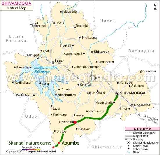
Route Map
Image courtesy : Maps of India

Subscribe via email

Please subscribe to get regular updates from my blog ...

Enter your email address:

Delivered by FeedBurner